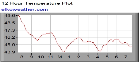
Current Conditions at KMNELKO1 at 14:55:19 8/2/2026
Temperature: 83.6°F (increasing)
Humidity: 55%
DewPoint: 65.7°F
Wind Calm
Barometer: 29.95 inHg (falling)
Heat Index: 85.7°F
Daily Rain: 0.00"
High Temperature: 84.1°F at 14:10
Normal High Temperature: 83°F
Low Temperature: 59.6°F at 6:07
Normal Low Temperature: 65°F
Record High Temperature: 99°F (in 1988)
Record Low Temperature: 46°F (in 1971)
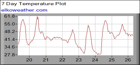
Yesterday:
High Temperature: 83.4°F at 13:19
Low Temperature: 61.3°F at 6:19
Rain: 0.00


